Warenkorb leer.

Sachgebiete:

Geisteswissenschaften Sozialwissenschaften Literatur Natur- + angewandte Wiss. Kunst, Musik Laender, Geschichte Varia Buchwesen, Bibliophilie


Ihre Suche nachart: 7528 Titel gefunden
Seite 12 von 377
letzte Eingänge art
Atlantis .:. 1960/11
Atlantis 1954/07. Länder/Völker/Reisen. Spanische Reitschule. Zürich: Atlantis, 1960. XI, Seite 509-558, XIII-XX mit Abbildungen. Kartoniert. 4to. 256 g * Mit beigelegten Zeitungsartikeln. - Untere Ecke mit leichten Knitterspuren.
Atlantis | Zeitschriften | Periodicals | Reitschule | Hippologie
Buchnummer 153743 CHF 15.00 | EUR 16.35
Atlantis .:. 1962/12
Atlantis 1962/12. Länder / Völker / Reisen. 34. Jahrgang, Heft 12. Zürich: Atlantis, 1962. XVI Seiten 637-731, XXI-LIV mit Abbildungen. Kartoniert. 4to. 612 g * Herausgegeben von Martin Hürlimann. Thema: Hirten. - Untere Ecke etwas bestossen.
Atlantis | Zeitungen | Zeitschriften | Hirten
Buchnummer 155808 CHF 15.00 | EUR 16.35
Atlantis 1964/01. Laender/Voelker/Reisen.
Atlantis 1964/01. Länder/Völker/Reisen.
Atlantis 1964 | Biologie | Anthropologie | Biology | Anthropology | Kunst | Arts
Buchnummer 45593 CHF 12.00 | EUR 13.08
Atlantis 1964/04. Laender/Voelker/Reisen.
Atlantis 1964/04. Länder/Völker/Reisen. Indien.
Atlantis 1964 | Biologie | Anthropologie | Biology | Anthropology | Kunst | Arts | Indien
Buchnummer 45595 CHF 12.00 | EUR 13.08
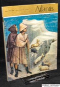
Atlas .:. des Universums
Moore, Patrick, Der grosse Atlas des Universums. Planeten, Sonnensysteme, Galaxien, unser Weltall in mehr als 800 Karten, Farbfotos, Zeichnungen und Diagrammen. München: Mosaik-Verlag, 1990. 271 Seiten mit Abbildungen und Register. Pappband (gebunden) mit Schutzumschlag. Gross- 4to. 2151 g * Aus dem Englischen von Werner E. Celnik ... Bearb. der dt. Ausgabe: Rhea Lüst. Illustriert : Paul Doherty .... - Schwache Gebrauchsspuren.
ISBN 3-570-04626-5 | Atlas | Astronomie | Atlanten | Geodaesie | Kartographie |
Buchnummer 132561 CHF 35.00 | EUR 38.15
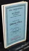
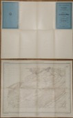
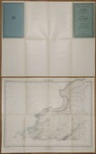
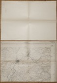
Atlas .:. zu G. Studer's Topographischen Mittheilungen
[Studer, Gottlieb, 1804-1890] Atlas zu G. Studer's Topographischen Mittheilungen. 1e Sammlung. Bern: Huber, [1843]. 5 gefaltete Blätter, lithogaphierte Panoramen. Kartonmappe, 18 x 12 cm. 89 g * Gemäss Innendeckel umfasst diese erste Sammlung 6 Ansichten; davon sind hier vorhanden: II: Von der Gamchilüke. 18 x 38 cm; IV: Aussicht vom Gipfel der Jungfrau, gegen Osten. 18 x 64 cm; V: Rundsicht vom Aeggischhorn im Wallis. 3 Blätter, zusammen 18 x 193 cm. - Schwach stockfleckig, die 3 Blätter "Aeggischhorn" mit Reisszweckenlöchern, Rückenkanten leicht aufgeplatzt, Rücken leicht gebräunt und von Hand beschriftet.
Atlas | Geodaesie | Kartographie | 1800-1849 | Helvetica | Schweiz | Geogr Berge | Alpinismus | Alpinistik
https://comenius-antiquariat.ch/buch/121482.html
Buchnummer 121482 CHF 250.00 | EUR 272.50
Atlas der Schweiz .:. interaktiv
Hurni, Lorenz u.a. [Red.], Atlas der Schweiz interaktiv. 3D-Topografie und Statistikkarten = Atlas de la Suisse interactif [...]. Wabern: Bundesamt für Landestopographie, 20. 1 CD-ROM + Begleitbuch (64 S.: Illustrationen, graph. Darst., Kt.). Schachtel 22 x 16 x 2 cm. 272 g * Systemvoraussetzungen Apple PowerMacintosh: PowerPC-Prozessor; mind. 35 MB freier Arbeitsspeicher (RAM); System Mac OS 8; CD-ROM-Laufwerk; Grafikkarte mit 16 oder 24 Bit Farbauflösung (True color); Farbmonitor mit mind. 800 x 600 Bildpunkten Systemvoraussetzungen IBM-kompatibler Computer (PC): Pentium-Processor; mind. 35 MB freier Arbeitsspeicher (RAM); Windows 95/Windows98, NT4.0; CD-ROM-Laufwerk; SVGA-Grafikkarte mit 16 oder 24 Bit Farbauflösung; Farbmonitor mit mind. 800 x 600 Bildpunkten. Text deutsch, englisch, französisch und italienisch. - Buch mit schwachen Gebrauchsspuren.
ISBN 3-302-09520-1 | ISBN-13 978-3-302-09520-2 | Atlas der Schweiz | Helvetica | Schweiz | Geodaesie | Kartographie
Buchnummer 152593 CHF 45.00 | EUR 49.05
Atlas topographique .:. 461 Chateau d'Oex
Atlas topographique de la Suisse (Atlas Siegfried), 461 Château d'Oex. Berne: Service topographique fédéral, 1919. Karte mehrfarbig, 1:25 000. 35 x 44 cm. 22 g * Name und Jahr auf dem Deckblatt.
Atlas topographique | Geodaesie | Kartographie | Helvetica | Schweiz | Siegfriedatlas | Siegfriedkarte
Buchnummer 152191 CHF 20.00 | EUR 21.80
Atlas topographique .:. Bulle
Atlas topographique de la Suisse, Feuille 362. [Bulle]. Berne: Service topographique fédéral, 1884. Karte mehrfarbig, 1:25 000. 28 x 39 cm. 12 g * Deckblatt von Hand beschriftet, leicht gebräunt, wenige Markierungen.
Atlas topographique | Geodaesie | Kartographie | Helvetica | Schweiz | Siegfriedatlas | Siegfriedkarte
Buchnummer 153439 CHF 15.00 | EUR 16.35
Atlas topographique .:. Combremont
Atlas topographique de la Suisse, Feuille 340. Combremont. Berne: Service topographique fédéral, 1919. Karte mehrfarbig, 1:25 000. 40 x 42 cm. 19 g * Deckblatt von Hand beschriftet, etwas gebräunt und knitterig, rechts randlos.
Atlas topographique | Geodaesie | Kartographie | Helvetica | Schweiz | Siegfriedatlas | Siegfriedkarte
Buchnummer 153458 CHF 15.00 | EUR 16.35
Atlas topographique .:. Farvagny
Atlas topographique de la Suisse, Feuille 346. [Farvagny]. Berne: Service topographique fédéral, 1884. Karte mehrfarbig, 1:25 000. 28 x 39 cm. 10 g * Deckblatt von Hand beschriftet, leicht gebräunt.
Atlas topographique | Geodaesie | Kartographie | Helvetica | Schweiz | Siegfriedatlas | Siegfriedkarte
Buchnummer 153436 CHF 15.00 | EUR 16.35
Atlas topographique .:. La Chaux-de-Fonds
Atlas topographique de la Suisse, Feuille 130: La Chaux-de-Fonds. Berne: Service topographique fédéral, 1931. Karte mehrfarbig, 1:25 000. 35 x 44 cm. 21 g * Schwache Gebrauchsspuren, schwach fleckig.
Atlas topographique | Geodaesie | Kartographie | Helvetica | Schweiz | Siegfriedatlas | Siegfriedkarte
Buchnummer 153504 CHF 16.00 | EUR 17.44
Atlas topographique .:. La Chaux-du-Milieu
Atlas topographique de la Suisse, Feuille 85: La Chaux-du-Milieu. Berne: Service topographique fédéral, 1925. Karte mehrfarbig, 1:25 000. 35 x 44 cm. 21 g * Leicht gebräunt, wenige Markierungen.
Atlas topographique | Geodaesie | Kartographie | Helvetica | Schweiz | Siegfriedatlas | Siegfriedkarte
Buchnummer 153505 CHF 16.00 | EUR 17.44
Atlas topographique .:. Lausanne
Atlas topographique de la Suisse, Lausanne et environs. Berne: Service topographique fédéral, 1922. Karte mehrfarbig, 1:25 000. 56 x 77 cm. 58 g * Report sur pierre 1909. - Gebrauchsspuren, Markierungen mit Rotstift, Besitzvermerk auf dem Deckblatt.
Atlas topographique | Geodaesie | Kartographie | Helvetica | Schweiz
Buchnummer 128932 CHF 15.00 | EUR 16.35
Atlas topographique .:. Le Locle
Atlas topographique de la Suisse, Feuille 83: Le Locle. Berne: Service topographique fédéral, 1926. Karte mehrfarbig, 1:25 000. 35 x 44 cm. 21 g * Schwache Gebrauchsspuren, leicht gebräunt.
Atlas topographique | Geodaesie | Kartographie | Helvetica | Schweiz | Siegfriedatlas | Siegfriedkarte
Buchnummer 153498 CHF 16.00 | EUR 17.44
Atlas topographique .:. Lully
Atlas topographique de la Suisse, Feuille 326. Lully. Berne: Service topographique fédéral, [ca. 1915]. Karte mehrfarbig, 1:25 000. 28 x 39 cm. 12 g * Deckblatt von Hand beschriftet, leicht gebräunt und knitterig, Stempel "REBUT", links und unten randlos.
Atlas topographique | Geodaesie | Kartographie | Helvetica | Schweiz | Siegfriedatlas | Siegfriedkarte
Buchnummer 153448 CHF 15.00 | EUR 16.35
Atlas topographique .:. Marly
Atlas topographique de la Suisse, Feuille 345. Marly. Berne: Service topographique fédéral, [ca. 1915]. Karte mehrfarbig, 1:25 000. 28 x 39 cm. 12 g * Deckblatt von Hand beschriftet, leicht gebräunt und knitterig, Stempel "REBUT", links und unten randlos.
Atlas topographique | Geodaesie | Kartographie | Helvetica | Schweiz | Siegfriedatlas | Siegfriedkarte
Buchnummer 153447 CHF 15.00 | EUR 16.35
Atlas topographique .:. Matran
Atlas topographique de la Suisse, Matran. Feuille 344. Berne: Service topographique fédéral, 1927. Karte mehrfarbig, 1:25 000. 40 x 50 cm. 19 g * 1886, revisée 1899, 1907, 1911. - Deckblatt von Hand beschriftet, Stempel "REBUT".
Atlas topographique | Geodaesie | Kartographie | Helvetica | Schweiz | Siegfriedatlas | Siegfriedkarte
Buchnummer 153434 CHF 15.00 | EUR 16.35
Atlas topographique .:. Payerne
Atlas topographique de la Suisse, Feuille 327. Payerne. Berne: Service topographique fédéral, [ca. 1915]. Karte mehrfarbig, 1:25 000. 28 x 39 cm. 12 g * Deckblatt von Hand beschriftet, leicht gebräunt und knitterig, Stempel "REBUT", links und unten randlos.
Atlas topographique | Geodaesie | Kartographie | Helvetica | Schweiz | Siegfriedatlas | Siegfriedkarte
Buchnummer 153449 CHF 15.00 | EUR 16.35
Atlas topographique .:. Riaz
Atlas topographique de la Suisse, Feuille 360. [Riaz]. Berne: Service topographique fédéral, 1885. Karte mehrfarbig, 1:25 000. 28 x 39 cm. 11 g * Deckblatt von Hand beschriftet, etwas gebräunt und knitterig, Markierungen.
Atlas topographique | Geodaesie | Kartographie | Helvetica | Schweiz | Siegfriedatlas | Siegfriedkarte
Buchnummer 153441 CHF 15.00 | EUR 16.35
Seite 12 von 377
<<  <  7  8  9  10  11  12  13  14  15  16  17  >  >>  

bibliopolis.ch @ Comenius-Antiquariat | Aktuell | Kontakt | Übersicht | © Samuel Hess |